Footpaths & Walks
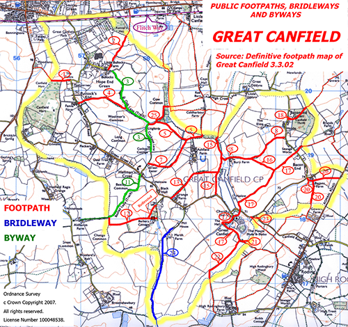
The adjacent map shows public footpaths, bridleways and byways in Great Canfield. You may also wish to see some “Canfield Walks” from one of our residents, Simon Mainwaring. These are introduced below.
Canfield Walks
The definition adopted here is that a "Canfield Walk" begins or ends within the parish boundaries but otherwise can roam all over the place. Each walk is tracked with GPS during the whole of the journey and the track is transferred to its unique Wikiloc page. This page then shows the track against the background of a satellite view or a map, and there is usually a short commentary. The GPS track can also be downloaded for on the spot guidance during the walk. For each walk there is a video, made up from a set of photos taken during the journey. This can be found through a link below or in the walk's Wikiloc page. The videos make extensive use of the footpath numbers shown in the map.
Most of the walks are circular and end up at the same place as they started. A few don't, such as the Dunmow to GC and GC to Molehill Green routes. For these, arrangements for pick-up or drop-off are needed. If there are two or more doing the walk it is of course possible to position a car at both ends of the walk beforehand. Similar arrangements could be applied when only doing a section of a circular route.
These are not particularly short walks, they cross open country, and surfaces can be uneven and rutted. Clothing should be appropriate to these conditions, and, as always, to the weather. Walking boots with good ankle support are strongly recommended.
So far there are 12 Canfield Walks in the collection - download brochure here . However this is not intended to be a one-man show, and others in the Great Canfield Community are welcome to add their own favourites.
Canfield Walks: Hope End to Hatfield Forest & back (9.6 miles)
http://www.wikiloc.com/wikiloc/view.do?id=7292094
https://www.youtube.com/watch?v=HDsng9DJEMw
Canfield Walks: “Crescent Wood” Circular (4.8 miles)
http://www.wikiloc.com/wikiloc/view.do?id=7613588
https://www.youtube.com/watch?v=P-0-e73X0tI
Canfield Walks: Philpot End - High Rodingbury Wood circular (6.1 miles)
https://www.wikiloc.com/wikiloc/view.do?id=19176444
https://www.youtube.com/watch?v=3Z2hQlCh4eY
Canfield Walks: Canfield to the Roding's source & the Three Horseshoes (8.1 miles)
http://www.wikiloc.com/wikiloc/view.do?id=7503539
https://www.youtube.com/watch?v=RHEKqffGwm4
Canfield Walks: Hatfield Broad Oak (Duke's Head) Circular (7.1 miles)
http://www.wikiloc.com/wikiloc/view.do?id=7447683
https://www.youtube.com/watch?v=61QObEN8CC0
Canfield Walks: Village Hall - Broomshawbury Circular (4.2 miles)
http://www.wikiloc.com/wikiloc/view.do?id=7123970
https://www.youtube.com/watch?v=pGvtD5GDTv4
Canfield Walks: Boxley Lane Circular (4.9 miles)
http://www.wikiloc.com/wikiloc/view.do?id=7350332
https://www.youtube.com/watch?v=sOpkXsWtols
Canfield Walks: Three Churches and a Windmill (5.6 miles)
https://www.wikiloc.com/wikiloc/view.do?id=19173918
https://www.youtube.com/watch?v=Ny8u-UfLPNg
Canfield Walks: Flitch Way Circular 2 (6.7 miles)
http://www.wikiloc.com/wikiloc/view.do?id=7210183
https://www.youtube.com/watch?v=uS75H9wJl9w
Canfield Walks: St Mary's, Dunmow to Bacon End (5.5 miles)
http://www.wikiloc.com/wikiloc/view.do?id=14222928
https://www.youtube.com/watch?v=FsCXklHhqi0
Canfield Walks: Flitch Way Circular 1 (7.5 miles)
http://www.wikiloc.com/wikiloc/view.do?id=7089017
https://www.youtube.com/watch?v=g-y4SASaMxw
Canfield Walks: High Roding Circular (5.9 miles)
https://www.wikiloc.com/wikiloc/view.do?id=19177688
https://www.youtube.com/watch?v=-TVyR6OPefg
Each walk is first posted in the Great Canfield Community Facebook group page at https://www.facebook.com/groups/greatcanfieldcommunity/?fref=ts (you will need to have a Facebook profile and become a Member of the group to access this). This site also provides an album of still photos for each walk. Just click on Photos and select the album that interests you. It also contains a reference to the page in Wikiloc described above.